Route no. 12 · start & finish Can Pastilla
Sa Calobra
- Epic
- 167 km
- 3,077 m
- ≈ 7½–9 h
Map and elevation profile
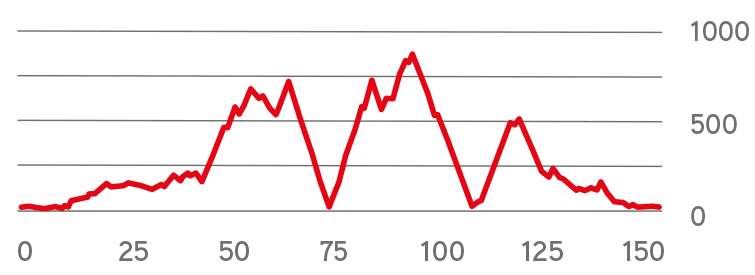
Move along the elevation profile to see where you are on the map.
Food & coffee stops
Tried-and-tested places where cyclists like to stop for coffee, food or water.
-
Café 44 kmSa Ruta Verda Caimari
Cycling café at the foot of Coll de sa Batalla since 2015: coffee, homemade vegan cakes, cycling kit and tools for quick fixes.
Open in maps ↗ -
Café 53 kmRestaurant Coll de sa Bataia (Repsol) Coll de sa Batalla (Escorca)
Classic cyclists' café by the Repsol station at the top of Coll de sa Batalla: self-service coffee, almond cake and baguettes, bike racks, tools, a track pump and water refills. Open daily 7:00–18:00.
Open in maps ↗ -
Café 62 kmBar Els Arcs Escorca (odbočka Ma-10 / Ma-2141)
Small bar under the aqueduct right at the Sa Calobra turn-off, passed on the way down and again after the climb back: freshly squeezed orange juice, coffee, cold drinks and bocadillos. Daily 9 am–7 pm; out of season, don't rely on it.
Open in maps ↗ -
Restaurant 78 kmRestaurant Es Vergeret Cala Tuent (Escorca)
Restaurant with a big terrace above the cove of Cala Tuent, at the end of a 5 km side road off the Sa Calobra road: paella, fresh fish and Mallorcan dishes with a sea view. Tue–Sun 12–4.30 pm, closed Mondays; booking advised.
Open in maps ↗ -
Restaurant 84 kmSes Taronges Sa Calobra
Right by the car park down in the cove. Eat and fill your bottles before the 9.5 km climb back up. Closed on Wednesdays and Thursdays.
Open in maps ↗ -
Café 118 kmCorel·la Café Fornalutx
Speciality coffee a few steps from Fornalutx's main square, on the descent from the reservoirs to Sóller: freshly squeezed orange juice, homemade lemonade, pastries and sandwiches. Open 9 am–4 pm, closed Wednesdays; if you arrive later, get your juice at Bar Depor on the square (closed Saturdays).
Open in maps ↗ -
Café 130 kmCa'n Topa Coll de Sóller
Orange juice and homemade cakes at the top of the day's last climb, with views over the Sóller valley.
Open in maps ↗
Sa Calobra, the Hilliest Terrain
Route summary:
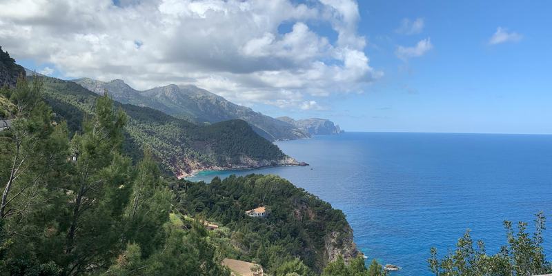
This is a route over demanding mountain terrain, and one of the hardest cycling challenges the island offers cyclists. It is only recommended for experienced cyclists who have already done some serious preparation. The ride takes between 7.5 and 9 hours depending on your average speed. Over this route, you will need to conquer several challenging climbs. The most demanding is a roughly 9.5-km-long climb from the Sa Calobra bay, which is well known to many cyclists. However, there is still another climb to come, the one to Coll de Sóller. This ride stands out due to the large number of tight turns and beautiful scenery around Tramuntana. The view from the saddle above Sa Calobra and the bay itself are breath-taking. On the way back, we recommend stopping to recharge your batteries in the towns along the way. Santa Maria del Camí is well known for its wine, Selva offers stunning views from the local cafés, the quiet cove of Cala Tuent has the Es Vergeret restaurant with a sea-view terrace (the main lunch stop), Sa Calobra has beautiful scenery and a bay, and in the mountain village of Fornalutx you can have a fresh orange juice on the square. There is also the town of Sóller with its vast orange gardens, and Bunyola with its breath-taking terraced gardens. On this route, it is important to pay attention to your energy intake and hydration.
 Cycling route summary:
In the initial 40 kilometers go through the inland to Inca. The beginning of the route has only a few slight uphills. It will warm you up for the long climbs. The first more difficult part starts from Selva and finishes at the Lluc monastery. It is a long climb through a pine forest, but it has a short, more relaxing passage in the middle. You will then climb to the pass above Sa Calobra. A serpentine descent towards Sa Calobra Bay will follow afterwards. We recommend paying more attention here to safety, due to higher traffic. About 2 km above the sea, turn off onto the road to Cala Tuent: it crosses the Coll de Sant Llorenç, with its 13th-century chapel, and drops to a quiet cove where the Es Vergeret restaurant sits on the slope above the sea – the main lunch stop. Climb back to the pass (3.4 km at around 6%), return to the junction and carry on all the way down to Sa Calobra Bay. After a short stop by the sea (fill your bottles), the most challenging part will follow. First, you will ascend the serpentines back to the pass above Sa Calobra, to a height of 720 m above sea level. Then you will do a short, easy part, leading to another, about 8 km climb with the beautiful view of lakes around. Next comes a descent of about 15 kilometres through the Tramuntana Mountains. Above Sóller you turn off the Ma-10 into the mountain village of Fornalutx for a fresh orange juice on the square, then follow the Ma-2121 down through the centre of Sóller. You will then climb to the Coll de Sóller. That climb will be the last challenge of the day. It will then be followed by a slight descent back to the final destination in Can Pastilla.
 Tourist summary:
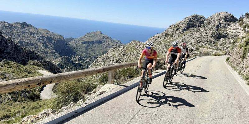
The zigzag climb to the village Sa Calobra in between steep cliffs, will show you a number of unforgettable views of the Sierra Tramuntana. However, they will take you into a few tricky sections of the climb, where you must be extremely careful. The MA-2141 road to Sa Calobra is sometimes called "Devil's Road".
Climbs click to show on the map
- Coll de sa Batalla from Caimari (Ma-2130) 9.2 km · Ø 4.7 % · max. 9.1 % · top 578 m km 43–52
- Coll de Sant Llorenç (Cala Tuent) from Cala Tuent 3.2 km · Ø 6.5 % · max. 10.7 % · top 227 m km 78–82
- Coll dels Reis (Sa Calobra) from Sa Calobra (0 m) 9.5 km · Ø 7 % · top 682 m km 85–94
- Puig Major (Túnel de Monnàber) from Gorg Blau (Ma-10) 4.9 km · Ø 5.6 % · top 885 m km 101–105
- Coll de Sóller from Sóller (Ma-11) 8.9 km · Ø 5.3 % · max. 9.5 % · top 497 m km 121–130
Tips from our guides
- The road to Sa Calobra is a dead end: every metre you descend you must climb back, 9.5 km at 7%. Descend calmly and eat beforehand in Cala Tuent.
- Tour coaches use the road from mid-morning and need its full width on the hairpins. Pull over and let them pass. Set off as early as you can.
- Below the summit of Puig Major you ride through the Monnàber tunnel (about 400 m). It is lit, but switch on your front and rear lights.
- Fill both bottles at Coll de sa Batalla and in Sa Calobra. The next 21 km, back up and on to the Monnàber tunnel, have no reliable water.
- At 885 m by the tunnel it is often several degrees cooler than at the coast. Pack a gilet or arm warmers for the 15 km descent to Sóller.
- Es Vergeret in Cala Tuent is closed on Mondays and serves food from about 12:15 to 16:30. Hours change with the season, so check ahead in winter; otherwise eat in Sa Calobra.
Did you know?
- The Sa Calobra road was designed by engineer Antoni Parietti and built between 1928 and 1933. He also built the road to Cap de Formentor. source
- At Lluc monastery, just off the route, the choir children are called Blauets after their blue cassocks (blau is Catalan for blue). The choir school dates from the 16th century. source
- The Gorg Blau and Cúber reservoirs you pass below Puig Major were inaugurated in 1972 and still supply drinking water to Palma. source
Places along the route
-
121 km
Santa Maria del Camí
The city is located in the heart of the wine region. The rich history of the wine distribution and the view of authentic Majorcan villages, are an unforgettable experience when visiting the city, especially for wine lovers.
-
233 km
Lloseta
Cycling enthusiasts certainly shouldn’t miss the fact that this rural town with a rich history is the birthplace of Olympic cyclist Miguel Martorell.
-
339 km
Mancor de la Vall
A quiet village at the foot of the Tramuntana Mountains, which the route passes through on the way to Caimari.
-
443 km
Caimari
The local olive oil is being sold in shops all over the island. The surrounding nature is also specific. There are many valleys in the Tramuntana Mountains around this place.
-
561 km
Puig Major view
If you ride on the mountain road connecting Pollenca with Soller, you will come to a road turn leading to Calobra Bay. The turn is just below the highest point of the island, Mount Puig. The view is just amazing.
Sa Calobra road
The construction of this road started in 1928 and lasted until 1933. Climbing up from the sea, you will gain about 670 meters in roughly 9.5 kilometers. The road turns at an angle of 270 degrees, at one point. This place got nicknamed ‘the tie knot’
-
677 km
Cala Tuent
A quiet pebble cove below Puig Major, the island’s highest mountain, just a few kilometres from busy Sa Calobra. The road there crosses the Coll de Sant Llorenç, with the 13th-century chapel of Sant Llorenç.
-
785 km
Sa Calobra
Sa Calobra could be specified as a number of spectacular perspectives. The canyon at the mouth of the Torrent de Pareis river is definitely worth a visit.
-
8118 km
Fornalutx
A stone-built mountain village above the Sóller valley, surrounded by orange and lemon groves. It belongs to the association of the Most Beautiful Villages in Spain, and on its square you can have a freshly squeezed orange juice.
-
9121 km
Sóller
The authentic town of Sóller is located in the heart of the "valley of oranges". The local citrus plants are well known all around the world. The oranges were exported from the nearby port to France, during the 19th century. That time, the area around Sóller, was isolated by mountains from the rest of Mallorca.
-
10139 km
Bunyola
Bunyola could be described as the “diverse nature, as far as your eye can see”. You will pass through the olive plants in the south. There are a large number of manors in the northern part, at the foot of the mountains. The most famous are Alfábia and Raixa. Their terraced gardens date back to the Arab period.
More routes
All routes →Rides of similar difficulty you might also like.